


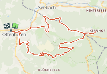
Karlsruher Grat

Claudele
User

Length
14.5 km

Max alt
844 m

Uphill gradient
718 m
Km-Effort
24 km

Min alt
298 m

Downhill gradient
718 m
Boucle
Yes
Creation date :
2022-07-23 07:38:59.166
Updated on :
2022-07-23 15:40:49.157
6h52
Difficulty : Very difficult

FREE GPS app for hiking
 SityTrail
IGN / Geographical institutes
SityTrail Plus
The world is yours!
About
Trail Walking of 14.5 km to be discovered at Baden-Württemberg, Ortenaukreis, Ottenhöfen im Schwarzwald. This trail is proposed by Claudele.
Photos


65 photos in total. Please click on a photo to see them all in the gallery.
Positioning
Country:
Germany
Region :
Baden-Württemberg
Department/Province :
Ortenaukreis
Municipality :
Ottenhöfen im Schwarzwald
Location:
Unknown
Start:(Dec)
Start:(UTM)
437331 ; 5379635 (32U) N.
Comments